Spanning 120,000 square miles across the Southwestern United States and northwestern Mexico, the Sonoran Desert supports 2,000 plant species and 550 vertebrate species. Giant saguaro cacti dominate the landscape, growing up to 250 years in valleys separated by barren rock mountains.
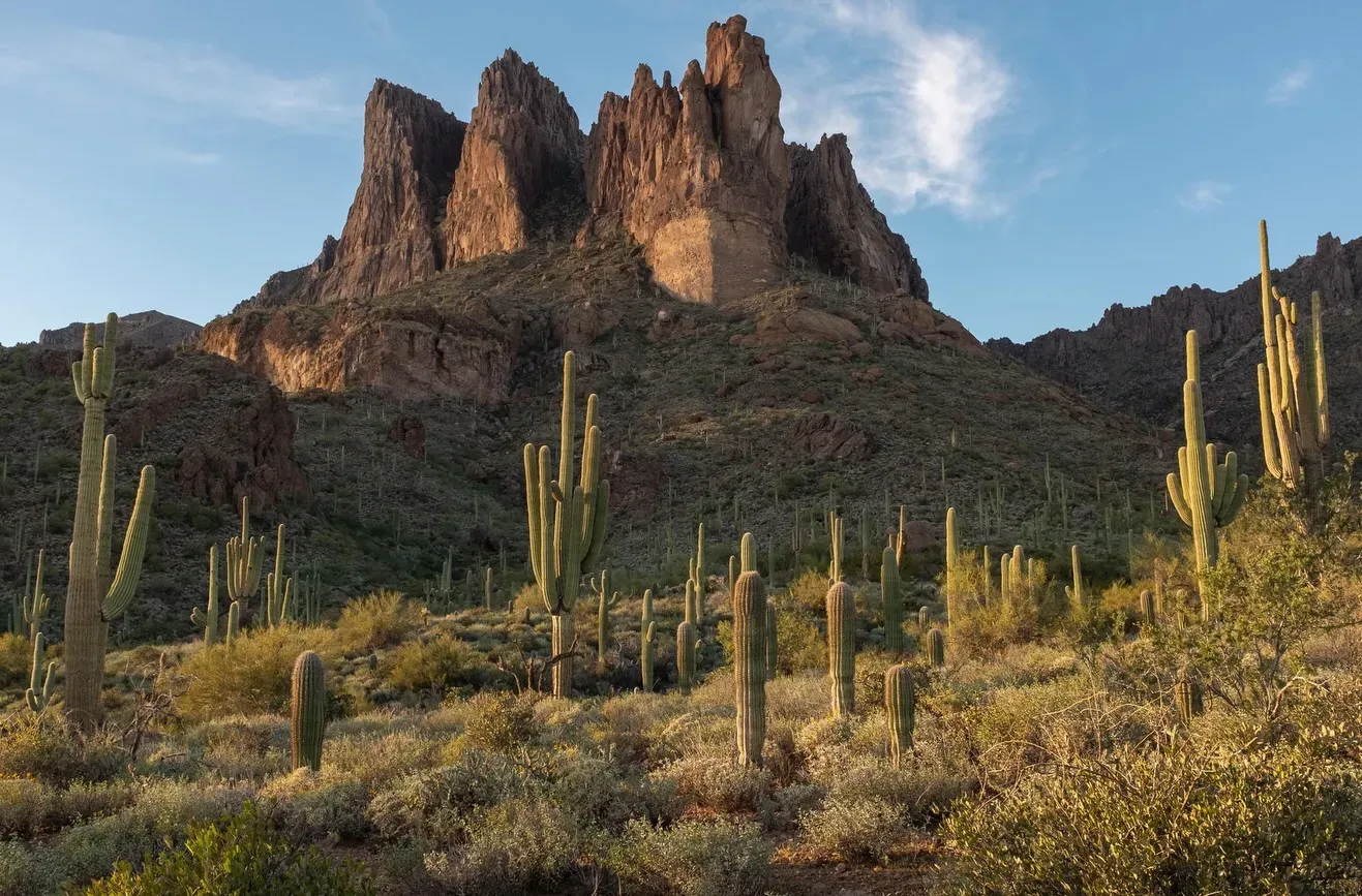
The Sonoran Desert covers 120,000 square miles across the Southwestern United States and northwestern Mexico. The landscape stretches from southern Arizona and southeastern California down into the Mexican states of Sonora and Baja California. Broad, flat valleys dominate the terrain, separated by widely scattered, barren mountain ranges. The Maricopa, Sand Tank, and Table Top mountains rise abruptly from the desert floor. Elevations shift drastically across the region. Near Yuma, the ground sits at sea level. In the eastern sky islands, peaks reach 10,000 feet before the desert transitions into high grasslands. The mile-high Mogollon Rim borders the northeast edge, creating a sharp geographic boundary.
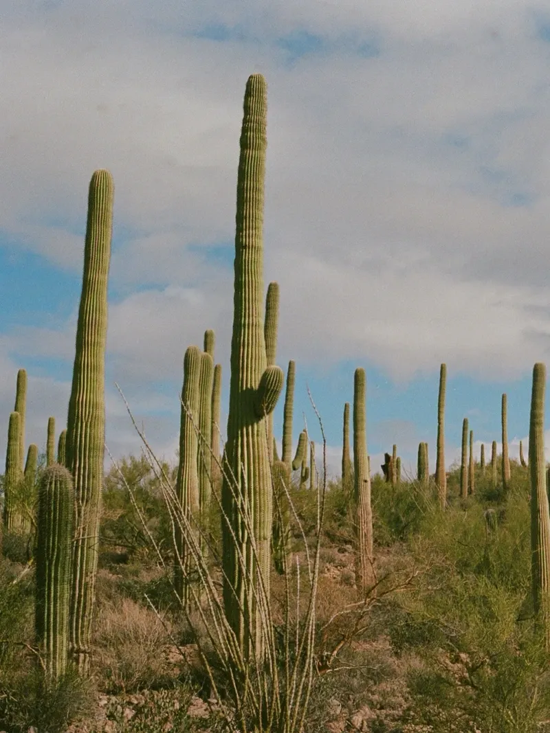
Two distinct rainy seasons fuel the highest biological diversity of any North American desert. Mild winters rarely bring frost, allowing sensitive succulents to thrive. Rain falls during late summer monsoons and gentle winter showers. This dual-season pattern sustains 2,000 plant species and 550 vertebrate species. Giant saguaro cacti define the horizon, growing exclusively in this ecoregion. These massive plants live up to 250 years, storing tons of water in their ribbed trunks to survive prolonged dry spells. Organ pipe cacti join them in the southern reaches, creating dense, towering forests of green spines.
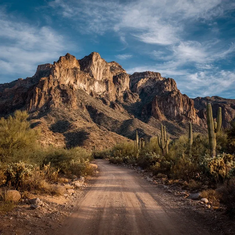
President Bill Clinton established the Sonoran Desert National Monument in 2001, protecting 496,337 acres southwest of Phoenix. The Bureau of Land Management oversees this vast territory. Visitors navigate over 460 miles of primitive, unpaved roads through the monument's central corridor. High-clearance vehicles kick up dust along routes that cross wide valleys and rugged mountain passes. Summer temperatures routinely exceed 110°F (43°C). Heatstroke poses a severe risk between May and September. Smart travelers arrive between late October and mid-April, bringing at least one gallon of water per person daily.
Accessibility varies greatly across the desert's attractions. The East Skip Rimsza Paseo trail at Apache Wash Trailhead features a paved concrete surface with a gradual incline, accommodating wheelchairs and elderly visitors. The Desert Botanical Garden in Phoenix offers electric scooter rentals and interactive exhibits for children. Further south, the Arizona-Sonora Desert Museum combines a zoo, botanical garden, and art gallery to showcase live desert animals and over 50,000 plants. Exploring the backcountry trails of the national monument requires physical endurance and careful preparation. Cellular phone signals drop completely in remote areas. Download digital maps and GPS routes before leaving the highway.
The modern communities of plants and animals in the Sonoran Desert formed just 4,500 years ago. The desert itself expanded to its current geographic boundaries around 9,000 years ago following the end of the last Ice Age. Volcanic activity shaped the terrain long before the flora adapted to the arid climate. The Pinacate volcanic field left behind massive craters and jagged lava flows. Wind patterns shifted over millennia, depositing fine sand to create the Gran Desierto de Altar sand sea. These geological forces created a harsh environment that forced species to evolve specialized water-conservation traits.
Ancient Hohokam people engineered extensive canal systems to farm the dry valleys. They cultivated agave, squash, and corn, leaving behind archaeological sites and petroglyphs that still dot the landscape. Spanish explorers arrived in the 16th century. They mapped the region, established missions, and introduced new livestock, permanently altering the indigenous way of life. The central corridor soon became a major transit route. Early Native Americans, homesteaders, and miners crossed the unforgiving terrain searching for water sources and precious metals. Abandoned mine sites remain scattered across the desert today. These unstable shafts pose severe cave-in hazards and often harbor dangerous wildlife like mountain lions and rattlesnakes.
During the 19th century, pioneers carved distinct paths through the sand and rock. The Mormon Battalion Trail and the Butterfield Overland National Historic Trail cut directly through the desert. Stagecoaches carried mail and passengers along the Butterfield route, connecting the eastern United States to California. Ruts from wagon wheels remain visible in some sections of the national monument today. Travelers faced extreme heat, scarce water, and rugged mountain passes. Walking these historic pathways offers a tangible connection to the pioneers who braved this arid landscape.
Urban expansion from Phoenix and Tucson threatened the desert ecosystem by the late 20th century. On January 17, 2001, the federal government designated 496,337 acres as the Sonoran Desert National Monument to enhance resource protection. The Bureau of Land Management now oversees this territory, focusing on preserving the fragile saguaro forests and critical wildlife habitats. Conservationists monitor the endangered Sonoran pronghorn and desert bighorn sheep populations. Dispersed camping is permitted for up to 14 days within any 28-day period. After 14 days, campers must move their campsite at least 25 miles away. Visitors must pack out all trash and inspect their sleeping bags for scorpions before use.
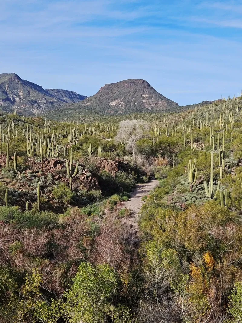
Broad, flat valleys dominate the Sonoran Desert, interrupted by abrupt, jagged mountain ranges. The Maricopa, Sand Tank, and Table Top mountains rise sharply from the desert floor. These barren rock formations lack foothills. They transition instantly from flat plains to steep, rocky inclines. Table Top Mountain, a prominent volcanic peak, features a flat basalt cap that stands out against the surrounding sky. Hikers climbing the Table Top Trail navigate loose rock and sharp elevation gains. The trail climbs through diverse desert vegetation, providing a rugged physical adventure. At the summit, hikers gain panoramic views of the dense saguaro forests covering the valleys below.
The Gran Desierto de Altar contains North America's largest active sand dune field. Star dunes reach heights of 300 feet, shifting constantly under the prevailing winds. Nearby, the Pinacate volcanic field displays hundreds of cinder cones and massive maar craters. The Elegante Crater measures nearly a mile across and drops 800 feet deep. Basalt flows from ancient eruptions create dark, rugged patches across the lighter desert soil. The North Maricopa Mountains Wilderness covers 63,200 acres of this terrain. Motorized vehicles and mechanical transport, including mountain bikes, are strictly prohibited by law in these designated wilderness areas.
Water shapes the landscape despite its scarcity. Dry washes carve deep channels through the valleys. These sandy riverbeds remain empty for months. When late summer monsoons hit, they fill with rushing water in minutes. Flash floods tear through narrow canyons, carrying debris and reshaping the terrain. Visitors hiking in low-lying drainage areas face extreme danger during storms, even if the rain falls miles away. Never drive across flooded roads. The washes also provide critical habitat for over 200 bird species. Patient observers can spot Gila woodpeckers nesting inside the trunks of dead saguaros.
The vegetation structure relies heavily on the saguaro cactus. These towering succulents act as ecological indicators, reflecting the health of the entire desert. A single saguaro can weigh several tons when fully hydrated. Their shallow root systems spread out widely just below the soil surface to catch every drop of rain. Collecting, removing, or damaging live or dead plants is illegal. To explore the Sand Tank Mountains south of Interstate 8, visitors must obtain a free Barry M. Goldwater Range permit online after watching a 13-minute safety video.
The Sonoran Desert sustains deep cultural ties for the Tohono O'odham Nation. Their ancestors, the Hohokam, mastered survival in this arid environment through complex irrigation networks. The saguaro cactus holds sacred status in Tohono O'odham traditions. Tribal members harvest the red fruit of the saguaro each summer using long poles made from cactus ribs. They boil the fruit into syrup and ferment it into wine for the annual rain-calling ceremony. This ritual marks the beginning of their new year and the arrival of the monsoon season. The health of the saguaro directly impacts the cultural practices of the indigenous communities.
Historic routes like the Juan Bautista de Anza trail represent a collision of cultures. Spanish colonizers marched through these valleys in 1775 to establish a settlement at San Francisco. Today, history enthusiasts walk these exact pathways, tracing the footsteps of early pioneers and Native Americans. The remnants of the Butterfield Overland trail serve as physical markers of westward expansion. Stagecoach stations once provided brief refuge from the punishing heat. The isolation of these routes highlights the physical endurance required to cross the desert before modern transportation.
The desert also shapes modern Southwestern identity. The silhouette of a giant saguaro against a fiery orange sunset defines the American West. Artists, writers, and photographers flock to the unpolluted skies of the national monument. Far from city lights, the Milky Way stretches across the dark horizon, offering a clear view of the stars. The Arizona-Sonora Desert Museum preserves this aesthetic by banning drones, ensuring the natural soundscape remains undisturbed. Professional photographers working in Scottsdale's McDowell Sonoran Preserve must secure a $50 daily permit and leave props like couches and tents behind.
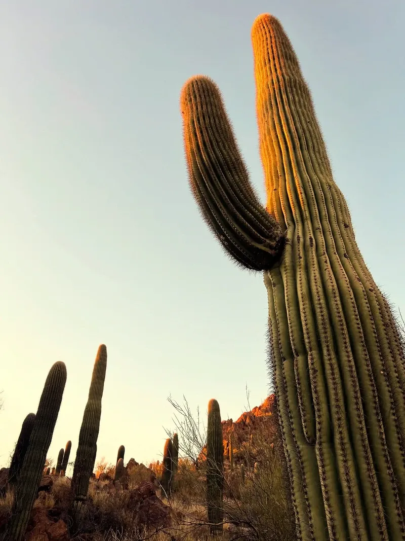
Saguaro cacti only grow in the Sonoran Desert and can live up to 250 years.
Over 200 bird species rely on the desert washes and mountain ranges for nesting and feeding.
The desert experiences a unique two-season rainfall pattern, fueling its high biological diversity.
The Gran Desierto de Altar features shifting star dunes that reach 300 feet in height.
The Pinacate volcanic field contains hundreds of cinder cones and deep maar craters.
Sonoran pronghorn inhabit the remote stretches of the national monument.
Motorized vehicles are strictly banned in designated wilderness areas to protect the landscape.
There are no entrance fees or passes required to visit the Sonoran Desert National Monument or its wilderness areas. Visitors must obtain a permit from the State of Arizona if they plan to recreate on nearby state trust lands.
The best time to visit is from late October to mid-April when the weather is mild. Summer temperatures regularly exceed 110°F, making outdoor recreation extremely hazardous during the hotter months.
Visiting the Sand Tank Mountains south of Interstate 8 requires a Barry M. Goldwater Range permit. This permit is free but must be obtained online after watching a mandatory 13-minute safety video.
Dogs are allowed on many trails, such as the Rio Salado pathway, but must be kept under control. Owners should be cautious of hot ground temperatures exceeding 100°F and sharp cacti that can injure paws.
There is no drinking water or trash collection available anywhere within the Sonoran Desert National Monument. Visitors must pack in all their water, planning for at least one gallon per person per day.
Dispersed camping is allowed for up to 14 days within any 28-day period. After 14 days, campers must move their campsite at least 25 miles away before setting up a new camp.
High-clearance or four-wheel-drive vehicles are highly recommended. Most roads within the monument are unpaved, primitive, and not maintained, causing standard passenger cars to struggle or get stuck.
Drone use is strictly prohibited at the Arizona-Sonora Desert Museum to protect the safety of animals and guests. In other areas, like the McDowell Sonoran Preserve, strict photography permits and rules apply.
Stop immediately, give the snake plenty of space, and allow it to move away on its own. Never attempt to handle, touch, or push the snake off the trail.
Motorized vehicles and mechanical transport, including mountain bikes, are strictly prohibited in designated wilderness areas. All vehicles must remain on existing, posted BLM routes.
Browse verified tours with free cancellation and instant confirmation.
Find Tours